Hang gliding and Paragliding is regulated by Transport Canada under CAR 602.29 which states in short that we can only operate in Class G airspace.
Transport makes the exception to be able to fly in Class E (controlled) airspace if you have a valid HAGAR (based on your medical)
First, what is Class E airspace?
“3.5.5. Controlled Airspace – Class E
Class E Airspace is designated where an operational need exists for controlled airspace but does not meet the requirements for Class A, B, C or D Airspace. Operations may be conducted under VFR or IFR. ATC separation is provided only to aircraft operating under IFR. There are no special requirements for VFR aircraft. Low-level airways, control area extensions, transition areas, or CZs established without an operating control tower may be classified as Class E Airspace.
Hang gliders and Paragliders can operate in VFR flight in Class E Airspace if the pilot is at least 16 years of age, is in possession of a Category 1, 3 or 4 medical certificate and has passed, or is exempted from writing, the HAGAR examination. In addition, the hang glider must be equipped with a magnetic compass and an altimeter, the flight must be a cross-country flight and the pilot must inform the nearest flight service station (FSS) of the time of departure and estimated duration of the flight in Class E airspace.”
Bottom line of the HAGAR is to make every Hang glider and Paraglider pilot aware of other air traffic (faster and IFR traffic) procedures and airspace regulations which will keep everyone safe while sharing the same airspace.
For H3/P3 pilots NOT having a HAGAR and like to go XC, the question is where and how high is Class G airspace?
In simple terms, Class G airspace is from the ground up to 12500 feet ASL or 18000 feet ASL
except if you are under an airway/air route, or under one of the shelves of airspace of a control zone around an airport.
How can you find out more about that?
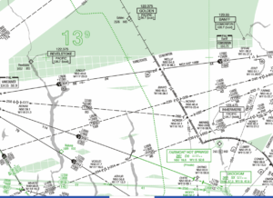
The easiest way to see which airspace you’ll be in, or at what altitude the controlled airspace starts is to have a look at the IFR Low En-Route Charts. VFR Navigation Charts (or VNCs) also give you the information but it is less apparent.
On IFR Low En-route Charts anything in
“Solid Green” means Class G is up to 18000 feet ASL
“Hatched Green” means Class G goes up to 12500 feet ASL
“White” means Class G goes up to 2200 feet (670 meters) AGL. This can be lower and is indicated at the VFR Navigation Charts
How does this apply to a XC flight from Golden to Canal Flats or further?
- Golden to about Parson is “Solid Green”, meaning Class G is up to 18000 feet ASL.
- Everything south from Parson is “White”, meaning Class G is only 2200 feet (670 meters) AGL.
- If you look at the VFR chart, south of Fairmont Class G is only 700 feet (213 meters) AGL.
I hope this will give everyone a more clearer picture and will show the benefit to have a HAGAR.
See the Low Level IFR En-Route Chart below.


