Columbia Valley Paragliding and Hang Gliding
The Columbia Valley Paragliding and Hang Gliding club is located at the headwaters of the Columbia River and maintains the following flying sites:
- Mt. Swansea – Invermere
- Panorama – Ski Resort
- Whitetale Mountain – between Canal Flats and Fairmont Hot Springs
- Mt. Seven – Golden (not maintained with us, but considered local)
- Mt. Swansea History – Out of the PastBy Winfried Weir
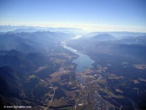
From the vantage point, you view the Rocky Mountain Trench, a linear topographic feature extending northerly almost 1500 km throughout the entire length of British Columbia, Canada
The Rocky Mountain region is actually the foothill region of the Rocky Mountains and extends from Golden to the Canada-USA border. The mountain range varies in high between 6000 – 12000 ft (1800m to 3650m), follows the Columbia River (one of the world’s great migratory bird sanctuaries) from Golden to it’s headwater at Columbia Lake and continues south following the Kootenay river to the border. The only major break in this mountain chain runs from Cranbrook to Sparwood.
The east side is developing almost continues thermals and perfect for long distance flights. Click here to see Google Map
The weather here is relatively dry in summer and with cloud bases in the 9000 feet to 15000 feet (2700 m – 4500 m) range, this area offers some of the best Cross Country potential in the Canadian Rocky Mountains.
Mt Swansea Webcam and wind Meter
West view of Mt. Swansea
[cam_images folder=”cam1″ count=”5″]
South view of Mt. Swansea
[cam_images folder=”cam2″ count=”5″]
2013 Wind meter, Webcam and launch site improvements
Project funded by:
- Recreation Sites and Trails BC
- BCHPA
- Columbia Basin Trust (25% of whole project)
- Western Economic Diversification Canada (50% of whole project)
With the help of Columbia Valley Cycling Society, Valley Chamber of Commerce, Ministry of Forests, Lands and Natural Resource Operations (Aina Cernenoks),lot of volunteer time of the local pilots, Lake Windermere Pointe (Webcam tower) and M & H Logging (for groundwork). Recognition for assistance is also due to District of Invermere, Regional District of East Kootenay


